Good morning. This is Doug Chabot with the Gallatin National Forest Avalanche Forecast on Thursday, March 24th at 6:45 a.m. This information is sponsored by Blitz Motorsports and Yamaha and Montana State Parks. This forecast does not apply to operating ski areas.
At 5 a.m. skies are partly cloudy, wind is west to southwest averaging 15-20 mph with gusts of 40 mph. Mountain temperatures are slightly above freezing in the Bridger Range at 9,000’ and barely below freezing elsewhere. Today will be sunny and westerly wind will blow 15-30 mph at the ridgetop. Temperatures are expected to rise into the low to mid 40s F. Cooke City will remain partly cloudy and could even get a trace of new snow.
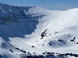
We are most concerned about wet avalanches today. The forecasted sunny skies is bad news. Small changes in today’s weather will have oversized consequences. Sunshine on slopes will quickly melt the surface crust that froze last night. Without wind blowing across the snow surface, melting will accelerate. Conversely, even a small breeze could help cool the snow. Temperatures are forecasted to be a few degrees cooler which might delay wet activity but not stop it. We are ripe for wet avalanches because the snow surface did not freeze thick and wet snow still exists under last night’s crust. Ian and Dave skied into Mt. Wheeler in the northern Gallatin Range yesterday and found wet snow that was unsupportable when they stepped out of their skies (video). Skiers in Hyalite saw a cornice break free because of warming and also saw many loose wet avalanches and one wet slab avalanche (details). I expect more of the same today from the Bridger Range to West Yellowstone. It’s time to turn around if you are sinking past your boot tops in wet snow or see wet-loose avalanches.
There are still plenty of slopes with dry snow on northerly facing high elevation slopes, but you’ll have to pass through low elevation wet snow to get there and return. It can still feel like winter up high and although we are most worried about wet avalanches, dry snow harbors a weakness a foot or two under the surface. In the last three days we found this layer of weak faceted snow on Mt Wheeler, Taylor Fork (video) and above Hebgen Lake (video). In dry snow we must dig to assess the stability.
Both wet and dry avalanches are possible today and the danger is rated MODERATE. However, if we get a trifecta of sunshine, no wind and mountain temperatures in the 40s, the wet snow avalanche danger would climb to CONSIDERABLE since widespread wet-loose and a few wet slab avalanches will occur.
Today, the mountains around Cooke City are not getting as warm or seeing as much sun as the other ranges. Clouds and a breeze will keep the snow surface from getting warm enough to avalanche. In dry snow there is a weak layer of sugary facets a foot or two under the surface. Skiers got two large collapses on this layer in Yellowstone National Park on Barronette Peak which is outside our forecast area (details). It was in a thin, 4 foot deep snowpack, but worth noting since similar conditions could be found in thinner snowpacks around Cooke City. For today, both wet and dry avalanches are unlikely and the danger is rated LOW.
If you get out, please send us your observations no matter how brief. You can submit them via our website, email (mtavalanche@gmail.com), phone (406-587-6984), or Instagram (#gnfacobs).
Upcoming Education Opportunities
See our education calendar for an up-to-date list of all local classes. Here are a few select upcoming events and opportunities to check out:
TONIGHT, Thursday, March 24, 6:30-7:30 p.m., 1-hour FREE lecture, Know Before You Go: Women’s Avalanche Awareness, Uphill Pursuits, Bozeman. More information HERE.
On March 19, two skiers were caught and one was killed in an avalanche near Steamboat Springs, Colorado (preliminary details). This was the fourth avalanche fatality in the U.S. in the past week and the fifteenth this season (https://avalanche.org/avalanche-accidents/).


